
Going the Distance
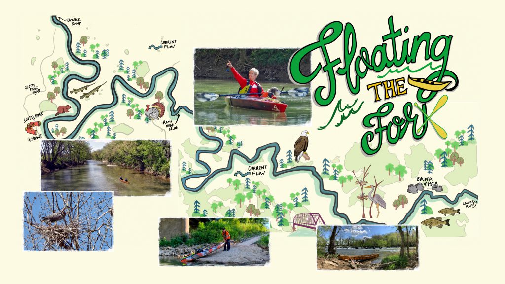
The 22-mile segment of the Rolling Fork River in Marion County, Kentucky that we’re inviting you to paddle extends from Calvary to Raywick, presented in two approximately 11-mile sections. Just below the community of St. Joe is the middle point. In the appropriate boat, with the appropriate equipment, each section is a great day trip.
The river in Marion County is considered the headwaters of the 108-mile-long Rolling Fork, which eventually joins the Salt River at the Hardin County and Bullitt County line.
The Rolling Fork in Marion County upstream of Calvary all the way to Bradfordsville is floatable only a very limited number of weeks of the year. The river is simply too shallow to float during most of the year.
From Calvary to the St. Joe mid-point (described here as Day Trip One) is floatable year round during a normal rainfall year. That’s primarily because deep holes are created by the Old Mill Dam. From the St. Joe mid-point to Raywick (Day Trip Two), even during normal rainfall years, water can become extremely shallow in July and August. You’ll likely be lining your boat often. Even then, the trip can be very enjoyable.
Day Trip 1
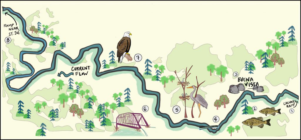
From the ramp at Calvary Dam off KY 208 to the ramp near St. Joseph, KY, at the bridge on KY 412 in Marion County, KY.
Total river miles: 11.09.
Travel time (water level and skill dependent): Advanced paddlers in efficient boats, five to six hours; recreational paddlers in 10-foot and under kayaks, eight to nine hours.
1.The put-in ramp at the Calvary Dam is a good one, complete with parking lot and public access.
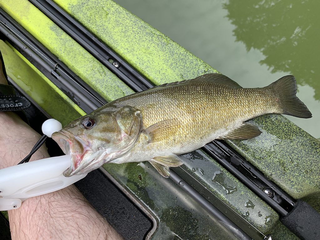
2.The smallmouth bass is actually a native of the Mississippi River basin; it’s also called bronzeback and smallie.
3.The pumping station at Buena Vista is no longer used, and is only started up every few years to make sure it still works.
4.Old Mill Dam is beautiful, but can be dangerous in high water. Portage on the right, moving downriver.
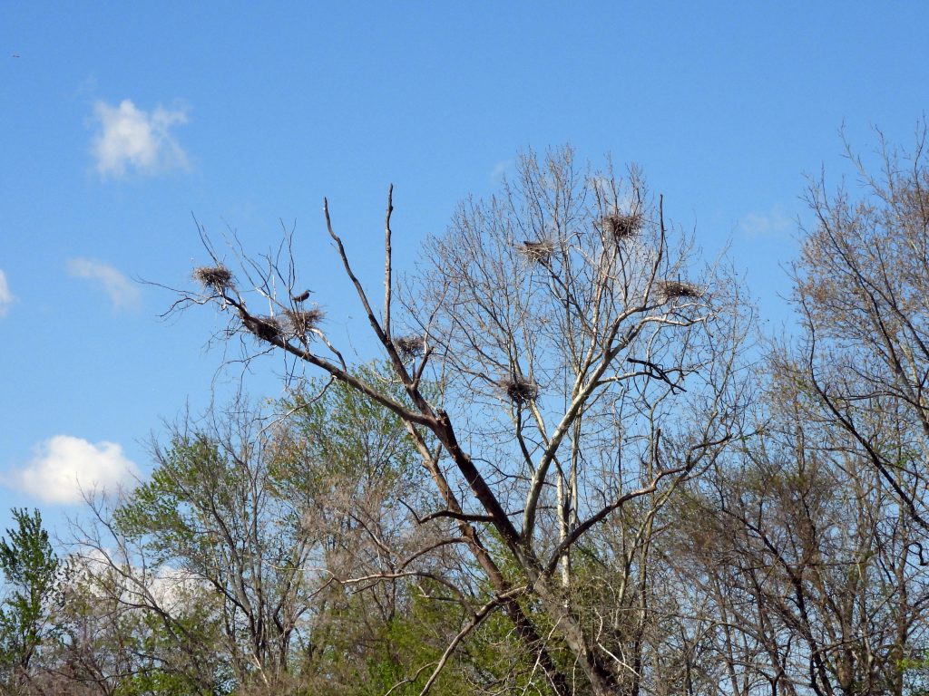
5.Heron rookeries are permanent colonies, and birds return each year to nest.
6.You’ll go under the iron bridge on KY 289. The length of the largest span of the Camelback Pratt through truss bridge is 149.9 feet.
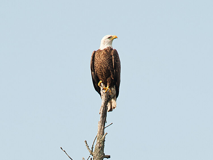
7.Bald eagles can be a fairly common sight, especially during spring and summer, on the Rolling Fork River.
8.The put-in/take-out ramp near St. Joe is a good one, and it’ll be on your right as you move downriver.
IMPORTANT: You will find online that under and near the KY 55/US 68 bridge is state right-of-way, and can be a put-in or take-out point. It is NOT recommended as part of Floating the Fork. Why? Because of water run-off from the bridge, the area, on the right-hand side going downstream, is deep—extremely deep—mud year-round. Put-in and/or take-out is extremely difficult.
Day Trip 2
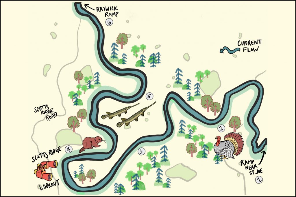
From the ramp near St. Joseph, KY, at the bridge on KY 412 in Marion County, to the ramp off KY 527/Scotts Ridge Road in Raywick, KY.
Total river miles: 9.55.
Travel time (water level and skill dependent): Advanced paddlers in efficient boats, five to six hours; recreational paddlers in 10-foot and under kayaks, seven to eight hours.
1.The put-in ramp is a good one, and is off KY 412 near the community of St. Joseph, KY.
2.The native wild turkey almost became extinct in Kentucky, but as a result of the Kentucky Fish and Wildlife Department, it’s back. You’ll likely hear, and maybe even see wild turkey (especially early mornings) on this stretch of the Rolling Fork.
3.Use your cell to track your progress so you’ll know when you’re entering Horse Shoe Bend.
4.Leaving in you car from Raywick, KY, and traveling south on KY 527/Scotts Ridge Road, you’ll find the beautiful Scotts Ridge Overlook. From the viewing ramp protected by video camera by the Marion County Sheriff’s Department, you’ll be able to see most of the river corridor you’re traveling by watercraft in this section.
5.The longnose gar is an ancient species of fish, and you’re very likely to see it in this section. Longnose gar can grow to 6-feet long and 50 pounds…just not likely in the Rolling Fork.
6.You’ll find the put-in/take-out ramp in Raywick on your right, after passing under the Scotts Ridge Road bridge over the river.
Important: As you approach the KY 527 bridge near the end of the trip near Raywick, there is a giant wall of logs and debris jammed against the bridge supports (as of July 2020) on the upstream side. Do not underestimate this challenge, especially in high water. The massive pile is some 25-feet high and stretches across the river.
Birding
Birding while Floating the Fork can be daunting, simply because of the challenge of keeping up with all the sightings. And if you’re identifying by bird song, prepare for a cascade of music.
Spring, summer and fall there’s a broad variety of birdlife. And even in winter, if you’re looking for duck species, you’ll find the opportunity to add to your birding life list.
In all seasons except winter you’ll find a flood of the usual characters: all the varieties of woodpeckers; Belted Kingfishers; White-Crested Nuthatch; Carolina Chickadees; Tufted Titmouse; and more. Veteran birders should expect to add to their life list among the sparrows, finches and perhaps even more, including waterbirds.
Between the KY 55/US 68 bridge and Old Mill Dam, there’s one of the largest heron rookeries in Central Kentucky. Great Blue Heron sightings are common throughout the river corridor.
Bald Eagles can frequently be found in that same zone, and actually almost anywhere along the river. And also Wild Turkey.
Having 8×42 binoculars is a good choice. The larger objective lens is a bit more ideal to deal with the river’s overhanging tree shadow zone, which is dark even on sunny summer days. A 10×42 can also be a good choice. But you need to be able to steady the view despite the rocking of your watercraft.
You can bring a spotting scope if you want, but since Bald Eagles are likely to perch less than 20 feet over you as you float under, it’s simply not needed.
Fishing
Before fishing, remember to check all Kentucky Department of Fish and Wildlife license and creel regulations. Department of Fish and Wildlife officers do patrol the three Floating the Fork ramps and on the river.
Fishing in the Rolling Fork River in Marion County can be very good to excellent, depending on the time of year and water flow.
In the upper day trip section described here, small mouth bass fishing from the dam at Calvary, near the put in, all the way to above and just below Old Mill Dam…is excellent. That’s primarily because of the limestone corridor through which the river flows. Also the high quality of the water, and the flora and fauna of the river play a part.
Target them with the method of your choice. Spinning rods, using Rooster Tails, especially black, work well. So do small crank baits. And worms or minnows? You bet. Fly fishing? Go for it.
And always remember: Catch and release is ethical, and helps guarantee a catch for the next fisherman.
In this same section, a Channel Catfish score can mean a big fish. Locals swear chicken livers deliver the most success.
In the lower day trip section described here, fishing remains very good to excellent in the pools between shallow gravel runs. You continue to find small mouth bass, as well as Rock Bass, various members of the sunfish family, Bluegill and more.
The Golden Rules of Floating the Fork
1. Respect Private Property
The public access, public ramps and public parking areas constructed at Calvary, near St. Joe, and in Raywick by the Marion County Fiscal Court, that’s what makes it possible for you to “Float the Fork.”
But remember during the entire time you are floating: All around you is private property.
In Kentucky, like most other states, courts have held that while landowners may own to the middle (“the thread”) of a particular stream or river, those riparian rights are subordinate to the public’s right to the use of navigable waters. A Kentucky case that still stands determined that the “public right of navigation” includes travel upon the waterways and also “the right to use the public waterways for recreational purposes such as boating, swimming and fishing.”
We, the Lebanon Tourist & Convention Commission, and all county and city entities involved in the Floating the Fork project, ask you to NOT abuse your recreational rights, and also RESPECT all private property.
Failure to do so will end Floating the Fork for all of us.
That’s why we define “public access and put-in and take-out points” for the purposes of “Floating the Fork” as: the ramp at Calvary; the ramp near St. Joe; and the ramp near Raywick.
2. Practice “Leave No Trace”
Leave no trace of trash behind, and leave no trace that you’ve been there.
That includes items such as any used toilet paper, drink containers, food wrappers, and even things such as discarded fishing line (yes, it strangles animals), lure boxes and empty bait containers.
In fact, plans are that future Floating the Fork projects involve organized volunteer public cleanup efforts. Please don’t make us clean up YOUR mess.
When you Float the Fork you’re encouraged to carry a container or plastic bag on your watercraft and pick up any trash you see. That’ll make Floating the Fork even more beautiful for all of us.
3. Protect Your Cellphone from Water & Carry First Aid
Yes, cell phone service is available throughout both day trip sections of Floating the Fork described here. But remember—in many places, especially in the Horseshoe Bend area, rescue access is difficult at best, and perhaps impossible in some places.
We also recommend you carry an extra paddle; and rope to be able to “line” your boat around and through obstacles and over shallows.
4. No Camping
Camping is not permissible on this river section without the express written or verbal consent, obtained in advance, of the landowner, whose property you will be trespassing on without that consent.
Safety
Potential Dangers
For conscientious watercraft operators,there are few dangers to identify, and Floating the Fork will be an enjoyable, memorable excursion. But there are things all boaters should keep first and foremost in their minds: sweepers and strainers, and high water.
Like all Kentucky rivers, the Rolling Fork experiences erosion which causes trees to uproot and fall into the river. The portion of the tree above the waterline is a sweeper, because it can “sweep” you from your boat. The portion below the waterline is a strainer, because it can snare you underwater.
Those who have had their watercraft go broadside into a sweeper and strainer, overturned and lost gear and almost lost their life, they know what a terrifying experience this can be. And strainers and sweepers are even more dangerous in high water.
There are no river gauges on the two day trip sections of Floating the Fork. So the only way boaters can confirm water conditions is by visually determining water levels while inspecting the river.
Take note that the two day-trip sections of Floating the Fork are in the upper Rolling Fork watershed. That means river water levels rise faster, and fall faster, in periods of high rainfall. At certain times of year, two inches of rain can make the Floating the Fork sections rage far beyond safe levels.
All boaters should know their skill level and know when to determine that a situation exceeds their skill level. Be smart. Do not embark on a river trip during high water levels after periods of heavy rainfall; watch for strainers and sweepers while navigating, and line your watercraft through or around, or portage; at home do research and expand your paddling skills; and always wear your life jacket while on the water.
Water Quality
The Lebanon Water Works Company treats approximately 2.2 million gallons of water a day at its treatment facility near Calvary, KY. The bulk of that raw water comes from the Rolling Fork.
“Generally speaking, we have a good, natural water source with the Rolling Fork,” said Daren Thompson, operations and management superintendent. Upstream is not heavily industrialized; and there are no environmental “hot spots” that cause serious contamination issues.
Like most streams in the rural Eastern United States, there is the issue of agricultural runoff, primarily high nitrogen levels causing algae problems. For Thompson, that must be solved at the treatment plant level.
“But the Rolling Fork is not only, generally speaking, a good natural raw water source, it’s also dependable, and predictable, during normal rainfall years,” he said.
On average, of every 30 days, the Rolling Fork provides the raw water for about 20 of those days; on the other days raw water is drawn from nearby Fagan Branch Reservoir, which was built as a backup raw water supply source.
(A note of interest: the Lebanon Water Works Company buys about 300,000 gallons of water a day from Campbellsville Water; about 60 percent of the water the Lebanon Water Works Company produces is sold to the Marion County Water District.)
Thompson likes to promote that the quality of the water treatment process performed by the Lebanon Water Works Company, using its quality raw water source, produces a very, very high-quality end product: some of the best drinking water in the state of Kentucky.